National Character Area profiles
Published 30 September 2014
Applies to England

© Crown copyright 2014
This publication is licensed under the terms of the Open Government Licence v3.0 except where otherwise stated. To view this licence, visit nationalarchives.gov.uk/doc/open-government-licence/version/3 or write to the Information Policy Team, The National Archives, Kew, London TW9 4DU, or email: psi@nationalarchives.gov.uk.
Where we have identified any third party copyright information you will need to obtain permission from the copyright holders concerned.
This publication is available at https://www.gov.uk/government/publications/national-character-area-profiles-data-for-local-decision-making/national-character-area-profiles
Use the links below to view each National Character Area (NCA) profile.
NCAs in north east England
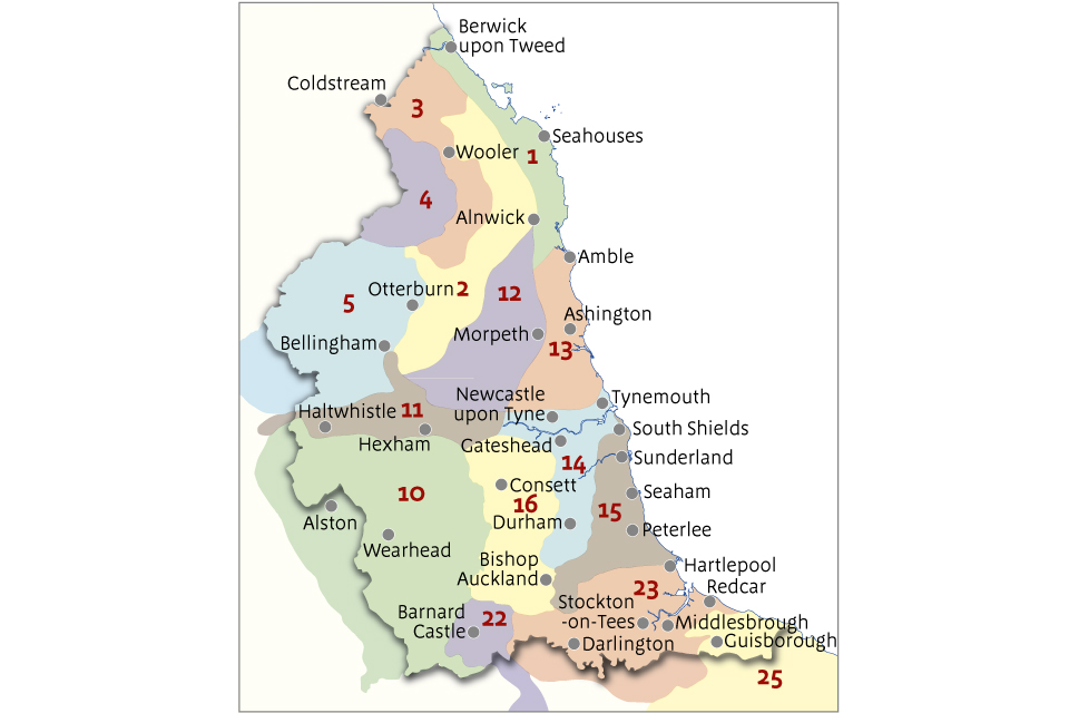
Use the map to find the relevant NCA then use the links below to view the profile.
- 1 North Northumberland Coastal Plain
- 2 Northumberland Sandstone Hills
- 3 Cheviot Fringe
- 4 Cheviots
- 5 Border Moors and Forests
- 10 North Pennines
- 11 Tyne Gap and Hadrian’s Wall
- 12 Mid Northumberland
- 13 South East Northumberland Coastal Plain
- 14 Tyne and Wear Lowlands
- 15 Durham Magnesian Limestone Plateau
- 16 Durham Coalfield Pennine Fringe
- 22 Pennine Dales Fringe
- 23 Tees Lowlands
- 25 North Yorkshire Moors and Cleveland Hills
NCAs in north west England
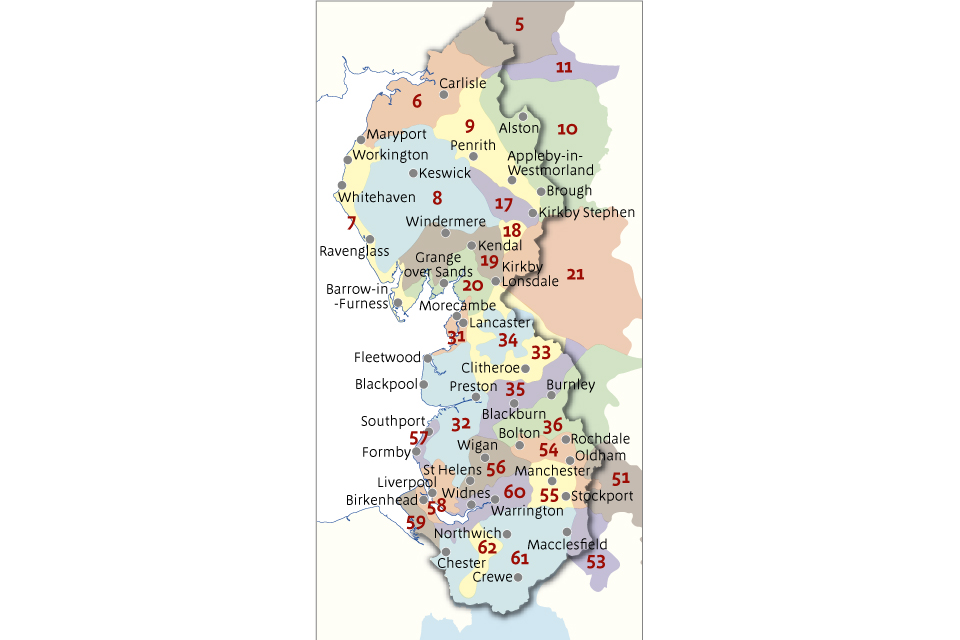
Use the map to find the relevant NCA then use the links below to view the profile.
- 5 Border Moors and Forests
- 6 Solway Basin
- 7 West Cumbria Coastal Plain
- 8 Cumbria High Fells
- 9 Eden Valley
- 10 North Pennines
- 11 Tyne Gap and Hadrian’s Wall
- 17 Orton Fells
- 18 Howgill Fells
- 19 South Cumbria Low Fells
- 20 Morecambe Bay Limestones
- 21 Yorkshire Dales
- 31 Morecambe Coast and Lune Estuary
- 32 Lancashire and Amounderness Plain
- 33 Bowland Fringe and Pendle Hill
- 34 Bowland Fells
- 35 Lancashire Valleys
- 36 Southern Pennines
- 51 Dark Peak
- 53 South West Peak
- 54 Manchester Pennine Fringe
- 55 Manchester Conurbation
- 56 Lancashire Coal Measures
- 57 Sefton Coast
- 58 Merseyside Conurbation
- 59 Wirral
- 60 Mersey Valley
- 61 Shropshire, Cheshire and Staffordshire Plain
- 62 Cheshire Sandstone Ridge
NCAs in Yorkshire and the Humber
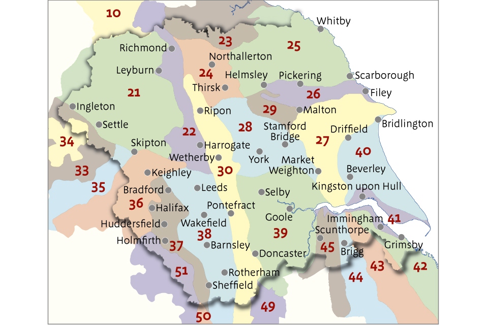
Use the map to find the relevant NCA then use the links below to view the profile.
- 10 North Pennines
- 21 Yorkshire Dales
- 22 Pennine Dales Fringe
- 23 Tees Lowlands
- 24 Vale of Mowbray
- 25 North Yorkshire Moors and Cleveland Hills
- 26 Vale of Pickering
- 27 Yorkshire Wolds
- 28 Vale of York
- 29 Howardian Hills
- 30 Southern Magnesian Limestone
- 33 Bowland Fringe and Pendle Hill
- 34 Bowland Fells
- 35 Lancashire Valleys
- 36 Southern Pennines
- 37 Yorkshire Southern Pennine Fringe
- 38 Nottinghamshire, Derbyshire and Yorkshire Coalfield
- 39 Humberhead Levels
- 40 Holderness
- 41 Humber Estuary
- 42 Lincolnshire Coast and Marshes
- 43 Lincolnshire Wolds
- 44 Central Lincolnshire Vale
- 45 Northern Lincolnshire Edge with Coversands
- 49 Sherwood
- 50 Derbyshire Peak Fringe and Lower Derwent
- 51 Dark Peak
NCAs in East Midlands
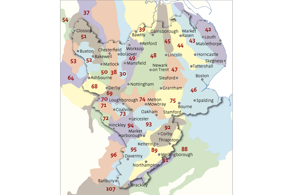
Use the map to find the relevant NCA then use the links below to view the profile.
- 30 Southern Magnesian Limestone
- 37 Yorkshire Southern Pennine Fringe
- 38 Nottinghamshire, Derbyshire and Yorkshire Coalfield
- 39 Humberhead Levels
- 42 Lincolnshire Coast and Marshes
- 43 Lincolnshire Wolds
- 44 Central Lincolnshire Vale
- 45 Northern Lincolnshire Edge
- 46 The Fens
- 47 Southern Lincolnshire Edge
- 48 Trent and Belvoir Vales
- 49 Sherwood
- 50 Derbyshire Peak Fringe and Lower Derwent
- 51 Dark Peak
- 52 White Peak
- 53 South West Peak
- 54 Manchester Pennine Fringe
- 64 Potteries and Churnet Valley
- 68 Needwood and South Derbyshire Claylands
- 69 Trent Valley Washlands
- 70 Melbourne Parklands
- 71 Leicestershire and South Derbyshire Coalfield
- 72 Mease/Sence Lowlands
- 73 Charnwood
- 74 Leicestershire and Nottinghamshire Wolds
- 75 Kesteven Uplands
- 88 Bedfordshire and Cambridgeshire Claylands
- 89 Northamptonshire Vales
- 91 Yardley Whittlewood Ridge
- 92 Rockingham Forest
- 93 High Leicestershire
- 94 Leicestershire Vales
- 95 Northamptonshire Uplands
- 96 Dunsmore and Feldon
- 107 Cotswolds
NCAs in West Midlands
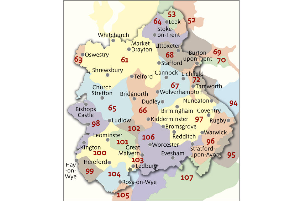
Use the map to find the relevant NCA then use the links below to view the profile.
- 52 White Peak
- 53 South West Peak
- 61 Shropshire and Staffordshire Plain
- 63 Oswestry Uplands
- 64 Potteries and Churnet Valley
- 65 Shropshire Hills
- 66 Mid Severn Sandstone Plateau
- 67 Cannock Chase and Cank Wood
- 68 Needwood and South Derbyshire Claylands
- 69 Trent Valley Washlands
- 70 Melbourne Parklands
- 72 Mease/Sence Lowlands
- 94 Leicestershire Vales
- 95 Northamptonshire Uplands
- 96 Dunsmore and Feldon
- 97 Arden
- 98 Clun and North West Herefordshire Hills
- 99 Black Mountains and Golden Valley
- 100 Herefordshire Lowlands
- 101 Herefordshire Plateau
- 102 Teme Valley
- 103 Malvern Hills
- 104 South Herefordshire and Over Severn
- 105 Forest of Dean and Lower Wye
- 106 Severn and Avon Vales
- 107 Cotswolds
NCAs in the east of England
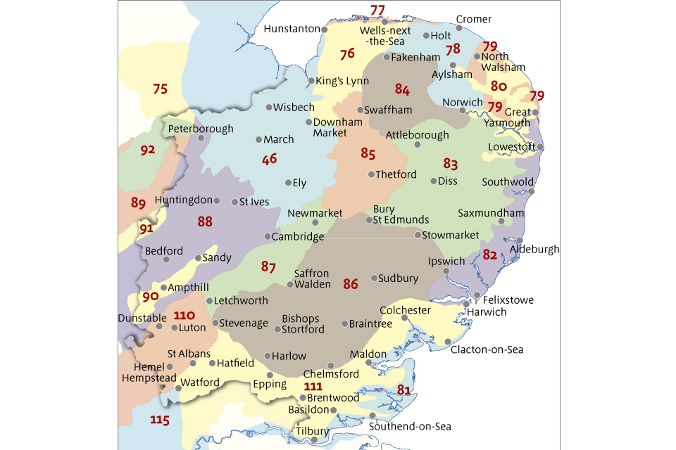
Use the map to find the relevant NCA then use the links below to view the profile.
- 46 The Fens
- 75 Kesteven Uplands
- 76 North West Norfolk
- 77 North Norfolk Coast
- 78 Central North Norfolk
- 79 North East Norfolk and Flegg
- 80 The Broads
- 81 Greater Thames Estuary
- 82 Suffolk Coast and Heaths
- 83 South Norfolk and High Suffolk Claylands
- 84 Mid Norfolk
- 85 The Brecks
- 86 South Suffolk and North Essex Clayland
- 87 East Anglian Chalk
- 88 Bedfordshire Claylands
- 89 Northamptonshire Vales
- 90 Bedfordshire Greensand Ridge
- 91 Yardley Whittlewood Ridge
- 92 Rockingham Forest
- 110 Chilterns
- 111 Northern Thames Basin
- 115 Thames Valley
NCAs in south east England and London
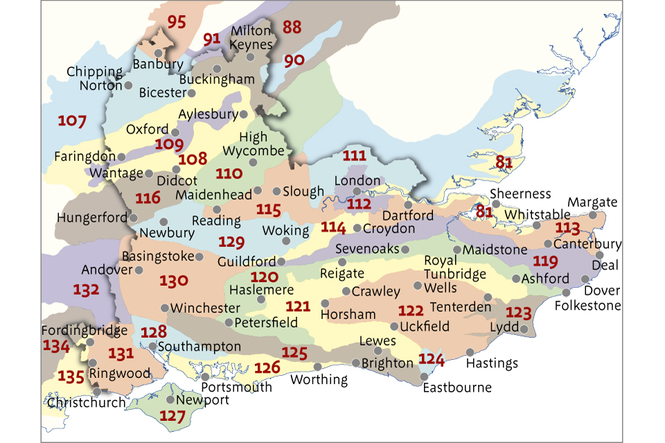
Use the map to find the relevant NCA then use the links below to view the profile.
- 81 Greater Thames Estuary
- 88 Bedfordshire and Cambridgeshire Claylands
- 90 Bedfordshire Greensand Ridge
- 91 Yardley Whittlewood Ridge
- 95 Northamptonshire Uplands
- 107 Cotswolds
- 108 Upper Thames Clay Vales
- 109 Midvale Ridge
- 110 Chilterns
- 111 Northern Thames Basin
- 112 Inner London
- 113 North Kent Plain
- 114 Thames Basin Lowlands
- 115 Thames Valley
- 116 Berkshire and Marlborough Downs
- 119 North Downs
- 120 Wealden Greensand
- 121 Low Weald
- 122 High Weald
- 123 Romney Marshes
- 124 Pevensey Levels
- 125 South Downs
- 126 South Coast Plain
- 127 Isle of Wight
- 128 South Hampshire Lowlands
- 129 Thames Basin Heaths
- 130 Hampshire Downs
- 131 New Forest
- 132 Salisbury Plain and West Wiltshire Downs
- 134 Dorset Downs and Cranborne Chase
- 135 Dorset Heaths
NCAs in south west England
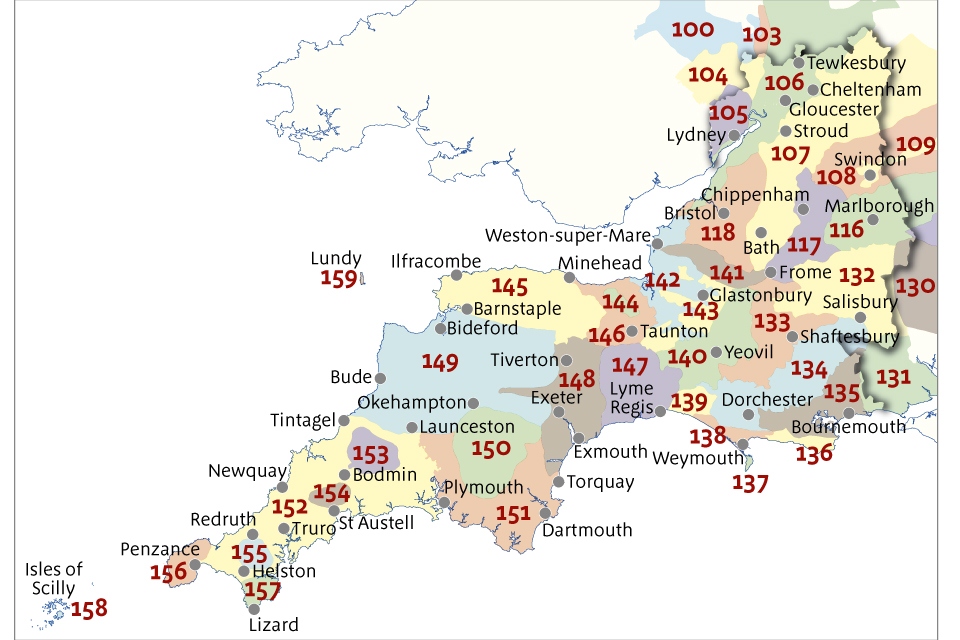
Use the map to find the relevant NCA then use the links below to view the profile.
- 100 Herefordshire Lowlands
- 103 Malvern Hills
- 104 South Herefordshire and Over Severn
- 105 Forest of Dean and Lower Wye
- 106 Severn and Avon Vales
- 107 Cotswolds
- 108 Upper Thames Clay Vales
- 109 Midvale Ridge
- 116 Berkshire and Marlborough Downs
- 117 Avon Vales
- 118 Bristol, Avon Valleys and Ridges
- 130 Hampshire Downs
- 131 New Forest
- 132 Salisbury Plain and West Wiltshire Downs
- 133 Blackmoor Vale and Vale of Wardour
- 134 Dorset Downs and Cranborne Chase
- 135 Dorset Heaths
- 136 South Purbeck
- 137 Isle of Portland
- 138 Weymouth Lowlands
- 139 Marshwood and Powerstock Vales
- 140 Yeovil Scarplands
- 141 Mendip Hills
- 142 Somerset Levels and Moors
- 143 Mid Somerset Hills
- 144 Quantock Hills
- 145 Exmoor
- 146 Vale of Taunton and Quantock Fringes
- 147 Blackdowns
- 148 Devon Redlands
- 149 The Culm
- 150 Dartmoor
- 151 South Devon
- 152 Cornish Killas
- 153 Bodmin Moor
- 154 Hensbarrow
- 155 Carnmenellis
- 156 West Penwith
- 157 The Lizard
- 158 Isles of Scilly
- 159 Lundy
NCAs by geographical boundaries
These maps allow NCA boundaries to be compared with other geographical boundaries:
- map of NCAs and local authority boundaries
- map of NCAs and Water Framework Directive management catchment boundaries
- map of NCAs and protected landscape boundaries
Data and information included in the profiles
See the supplementary information for details of the data sources and how it has been used in the NCA profile documents.
A glossary is available to explain the specialist terms used in the profiles.
Other sources of information
Local landscape character assessments provide further information about landscape character at county or district level. This is available in the Landscape Character Network database on Natural England’s archive website.